Best Hikes on São Miguel: Difficulty, Duration & Local Notes
A local ranks the best hikes on São Miguel by difficulty, duration, and scenery — from Lagoa do Fogo descent to Sete Cidades rim trail, with honest notes.
São Miguel has more than 30 official hiking trails (the “PR” — Pequena Rota network), plus a handful of unofficial paths that locals use. You don’t need to hike all of them. Most visitors have time for 2-3 hikes in a week, and choosing the right ones makes the difference between “that was nice” and “that was the best day of the trip.”
Here are the hikes that are actually worth your time, ranked by how much they deliver per hour invested. Not alphabetical, not by difficulty — by payoff.
What are the best hikes on São Miguel?
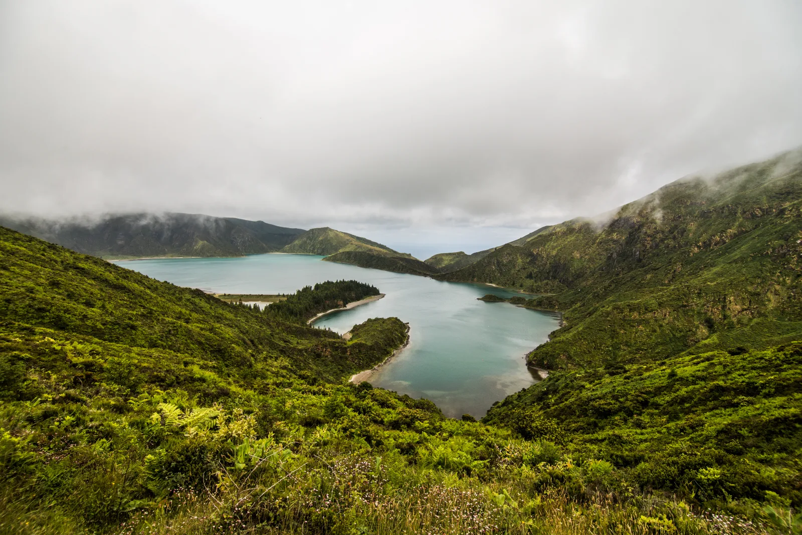
1. Lagoa do Fogo — Praia trail (PR02)
The best hike on São Miguel. No contest.
| Detail | Value |
|---|---|
| Distance | 4.5 km out-and-back |
| Duration | 1h down, 1.5h up |
| Elevation change | 300m descent |
| Difficulty | Moderate (steep, loose gravel in places) |
| Trailhead | Praia parking area, 35 min from Ponta Delgada |
You descend from the crater rim through dense vegetation into the caldera, and at the bottom find a white-sand beach on the shore of São Miguel’s most pristine lake. On a clear morning with no one else there, it’s one of the most beautiful places on the island.
Full details in the Lagoa do Fogo guide.
Local tip: Go early (before 9am). The caldera fills with cloud even faster than Sete Cidades. Bring water — there’s nothing at the lake.
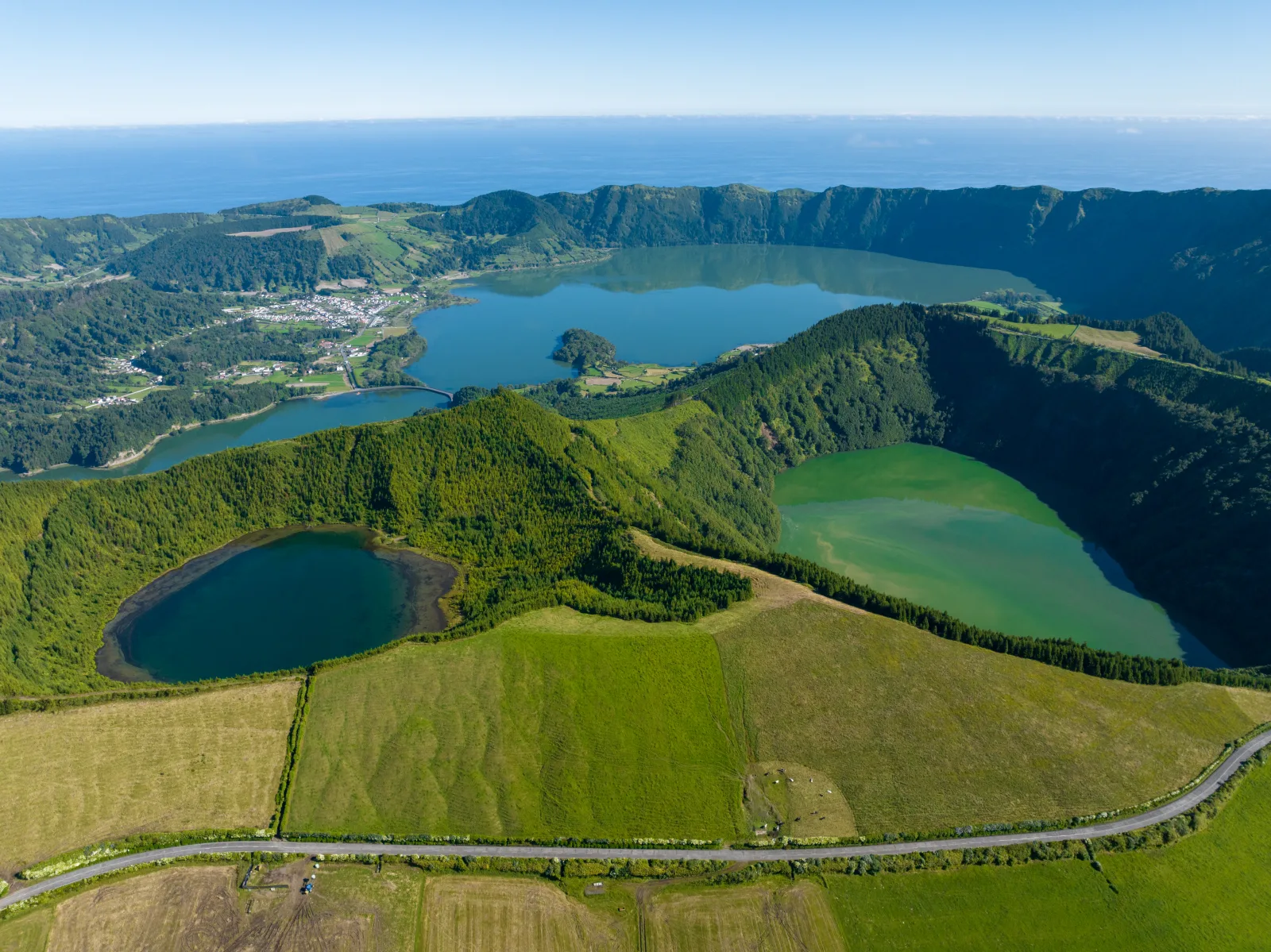
2. Sete Cidades rim trail (PR03 partial)
The classic crater rim walk. The full PR03 loop is 12 km, but the best section is the western rim from Vista do Rei heading south — about 3 km each way, 1 hour out, 1 hour back.
| Detail | Value |
|---|---|
| Distance | ~6 km out-and-back (partial) |
| Duration | 2-2.5 hours |
| Elevation change | ~200m rolling |
| Difficulty | Moderate (exposed ridge, wind) |
| Trailhead | Vista do Rei car park |
You walk along a knife-edge ridge with the twin lakes of Sete Cidades dropping away below you on one side and the Atlantic Ocean on the other. The views are non-stop for the entire walk.
Local tip: Wind on the rim can be strong, even when it’s calm in the village below. Bring a windbreaker. Don’t do this if fog is forming — walking a narrow ridge in zero visibility is not fun.
3. Salto do Prego waterfall trail
The best “hidden” hike on São Miguel. A walk through subtropical forest to a 20m waterfall with a swimmable pool at the base.
| Detail | Value |
|---|---|
| Distance | ~6 km out-and-back |
| Duration | 2-3 hours |
| Elevation change | ~150m |
| Difficulty | Easy-moderate (flat trail, can be muddy) |
| Trailhead | Faial da Terra village (southeast coast) |
The trail follows a river through endemic Azorean forest — tree ferns, giant heather, laurel — and ends at the waterfall dropping into a green pool. You can extend it into a loop that passes through the abandoned village of Sanguinho (stone houses overtaken by forest — see our hidden gems guide).
Local tip: Drive time from Ponta Delgada is ~1 hour. Combine this with the east coast / Nordeste for a full day. Wear shoes that can handle mud.
4. Mata do Canário lake loop
A gentler alternative to the rim trail. This walk starts near the Sete Cidades viewpoints and descends through the Mata do Canário forest reserve (cryptomeria plantation + native laurel) to the lake shore, then loops back.
| Detail | Value |
|---|---|
| Distance | ~6 km loop |
| Duration | 2 hours |
| Elevation change | ~200m |
| Difficulty | Easy-moderate |
| Trailhead | Lagoa do Canário car park |
Less dramatic than the rim trail but more sheltered from wind and weather. The forest section is atmospheric — moss-covered trees, filtered light, bird calls. Good for a cloudy day when the rim is fogged in.
5. Pico da Vara summit
The highest point on São Miguel (1,103m) and the most demanding hike on the island. A full-day trail through the remote eastern highlands with the chance to spot the Azores bullfinch (Priolo) — one of Europe’s rarest birds, endemic to this specific mountain.
| Detail | Value |
|---|---|
| Distance | ~12 km out-and-back |
| Duration | 5-6 hours |
| Elevation change | ~500m |
| Difficulty | Hard (long, muddy, exposed summit) |
| Trailhead | Near Algarvia, east São Miguel |
Local tip: This is not a casual day walk. The trail is long, remote, often muddy, and the summit is exposed to weather that can change in minutes. Proper boots, rain gear, food, and water are mandatory. Go on a confirmed clear day. The reward is genuine wilderness — you won’t see another person for hours.
6. Monte Escuro to Lagoa das Furnas
A short, peaceful trail connecting the highlands above Furnas to the lake where the cozido pots cook underground. Mostly downhill through native laurel forest.
| Detail | Value |
|---|---|
| Distance | ~5 km one way |
| Duration | 1.5-2 hours |
| Elevation change | ~250m (mostly descent) |
| Difficulty | Easy-moderate |
| Trailhead | Monte Escuro (signposted from the Ponta Delgada–Furnas road) |
Local tip: Do this one-way — have someone drop you at the top or take a taxi, then walk downhill to the lake and get picked up (or walk the road back to the village, ~2 km). Combine with a Furnas day.
7. Ribeira dos Caldeirões coastal walk
A short, accessible walk through a restored watermill park near Nordeste on the east coast. Waterfalls, stone bridges, subtropical gardens, and a café.
| Detail | Value |
|---|---|
| Distance | ~2 km loop |
| Duration | 45 minutes |
| Elevation change | Minimal |
| Difficulty | Easy (paved paths, wheelchair-accessible sections) |
| Trailhead | Ribeira dos Caldeirões park, Nordeste |
This isn’t a “hike” in the serious sense — it’s a nature walk. But it’s beautiful, easy, free, and a perfect break on an east coast driving day. The watermill ruins and waterfalls are photogenic.
Trail conditions on São Miguel by season
The same hike can feel completely different in October vs February. Knowing what season delivers what is the difference between a memorable morning and a slog through cold mud. Here’s the local breakdown for the best hikes on São Miguel:
June through September is the prime window. Trails are dry, the loose-gravel sections of the Lagoa do Fogo descent are at their easiest, and the rim viewpoints clear before 9am most days. The downside: weekday mornings on Vista do Rei and the Sete Cidades rim get busy from late June through August. The Salto do Prego waterfall flows lower in late summer but the forest section stays cool.
April, May, October are the quiet local favourites. The crater walls glow green, the cloud window lasts an hour longer, and you can usually have most trailheads to yourself. Light rain is more common but most São Miguel paths drain well. The Monte Escuro forest is at its most atmospheric in May when the laurel canopy fills out fully.
November through March is the gambler’s season. Trails are wet, exposed sections genuinely slippery, and Pico da Vara’s exposed summit can deliver winter conditions with no warning. On the rare clear winter morning the visibility is extraordinary — you can sometimes see all the way across to Pico from the Sete Cidades rim. Bring trekking poles, accept that 1 in 3 attempts ends fogged out, and treat any clear day as a gift.
Permits, access and trail markings
São Miguel’s signposted hiking trails are part of the regional PR (Pequena Rota) network maintained by the Azores parks service. They’re marked with red-and-yellow stripes painted on rocks, trees, and signposts. Most trails are free, with only a few exceptions:
- Caldeira Velha charges a small entry to the forest reserve (around €10 for a 90-minute session). The trail past the thermal pool to the upper caldera is included.
- Ilhéu de Vila Franca’s walking circuit requires the ferry crossing (booked online in advance during summer).
- All other trails on this list are free, accessible year-round, and require no permit.
Trail closures happen after heavy storms — landslides on the Lagoa do Fogo descent, fallen trees on Salto do Prego, and damage to the wooden boardwalks at Caldeira Velha are the most common issues. Check the trailsazores.com site or the Visit Azores app the morning of your hike for current closures. A trail marked closed is closed for a reason — don’t try to cross a barricaded section.
What to wear and bring (every hike)
- Shoes: Trail shoes minimum. Boots for Sete Cidades rim and Pico da Vara. Never sandals.
- Rain jacket: Yes, every time, regardless of forecast. Weather changes in 15 minutes.
- Water: 1L minimum. 2L for Pico da Vara.
- Layers: The rim trails are 5-8°C cooler and windier than the coast.
- Sun protection: The sun at higher elevations can be intense, even on days that start cloudy.
- Phone with offline maps: Cell service drops in valleys. Download the trail map from trailsazores.com or save the Google Maps area offline.
Quick comparison table
| Hike | Time | Difficulty | Best for |
|---|---|---|---|
| Lagoa do Fogo Praia | 2.5h | Moderate | Best payoff per hour, lake + beach |
| Sete Cidades rim | 2-2.5h | Moderate | Iconic views, twin lakes + ocean |
| Salto do Prego | 2-3h | Easy-moderate | Waterfall, forest, abandoned village |
| Mata do Canário | 2h | Easy-moderate | Forest atmosphere, bad-weather alternative |
| Pico da Vara | 5-6h | Hard | Remote wilderness, rare birds |
| Monte Escuro–Furnas | 1.5-2h | Easy-moderate | Combine with Furnas day |
| Ribeira dos Caldeirões | 45min | Easy | Families, quick stop, waterfalls |
The hikes most guides skip — but locals do
Beyond the seven trails ranked above, a few more São Miguel routes are worth knowing if you’ve already done the headline ones or you want something quieter:
Vigia da Baleia (whale-spotter trail) — A short clifftop walk above Caloura on the south coast, named after the old whale-watching huts that used to dot this stretch. About 4 km out and back, gentle elevation, with the Atlantic 100 metres below you the whole way. The reward isn’t the destination — it’s the bench at the turnaround point with a view that holds a good twenty minutes of just sitting. Quiet on weekdays, locals walk it on Sunday afternoons. The first time you do it, you’ll find yourself reading the swell pattern and picking out distant boats on the horizon for far longer than you planned. It is a different kind of hiking experience entirely, and a memorable one.
Faial da Terra to Salto do Prego (full circuit) — The popular waterfall hike most guides describe is just half this circuit. The full 8 km loop passes the Salto do Prego waterfall, the abandoned village of Sanguinho with its restored stone houses, and a second hidden waterfall (Salto do Cagarrão) that almost no visitor sees. Adds 90 minutes to the standard waterfall walk and is the better experience.
Ribeira do Guilherme — A short forest walk near Nordeste, one of the few São Miguel trails through the original native laurel forest that wasn’t cleared for cattle pasture. Damp, mossy, about 3 km, with a small waterfall at the turnaround. Best after rain when the moss is at its most vivid.
Furnas to Lagoa das Furnas via the south shore — Walk the road from Furnas village to the lake (~2 km), then the lakeside trail past the cozido pots and back. Counts as a hike on a rest day. Pairs naturally with cozido lunch — see the cozido das Furnas guide for booking details.
Pico do Carvão summit — A short, steep climb to a 750m volcanic peak in the central spine. Overshadowed by Pico da Vara but a third of the effort and very nearly the same view. Locals send first-time hikers here when Pico da Vara is fogged in.
How many hikes fit in a typical trip?
- 3-day trip: 1 hike — do the Lagoa do Fogo Praia trail
- 5-day trip: 2-3 hikes — add the Sete Cidades rim and/or Salto do Prego
- 7-day trip: 3-4 hikes — add Mata do Canário or Pico da Vara if you’re fit
See the 5-day itinerary or 3-day itinerary for how these hikes fit into a full trip plan.
For an itinerary that sequences these hikes with the rest of São Miguel’s highlights and adjusts for weather, Pocket Guide Azores builds it in one click.
What to read next
- Hiking in the Azores — the trails on the other islands, once you’ve outgrown São Miguel
- Thermal pools of São Miguel and Caldeira Velha — the local move is a hot soak after a hard hike
- Ponta da Ferraria — the geothermal sea pool, a different kind of recovery day
- Whale watching and scuba diving — the best non-hiking days to balance a trail-heavy trip
Frequently asked questions
What is the best hike on São Miguel? +
The Lagoa do Fogo Praia trail (PR02) — a 1-hour descent into a volcanic crater to a white-sand beach on the lake shore. It's the most dramatic payoff on the island: pristine lake, empty beach, and a climb back up that earns you the view. If you only hike once on São Miguel, do this one.
Are the hikes on São Miguel difficult? +
Most are moderate. The trails are well-marked, distances are short (2-12 km), and serious elevation gain is limited to a few trails. The main challenges are steep sections on loose gravel (Lagoa do Fogo descent), mud after rain (every trail), wind on exposed ridgelines (Sete Cidades rim), and fog that can roll in quickly at higher elevations.
Do I need hiking boots on São Miguel? +
Trail shoes with good grip are sufficient for most hikes. Hiking boots are recommended for the Sete Cidades rim trail and Pico da Vara summit (muddier, more exposed). Sandals and white sneakers are never appropriate — the volcanic terrain is rough and trails are frequently muddy. Waterproof shoes are a plus year-round.
Can I hike in São Miguel in winter? +
Yes, but with more precautions. Trails are muddier, rain is more frequent, and higher-elevation trails (Sete Cidades rim, Pico da Vara) can have low visibility. The upside: trails are empty, the landscape is intensely green, and waterfalls are at their fullest. Always carry a waterproof layer and check weather before starting.
Are São Miguel trails well marked? +
The official PR (Pequena Rota) trails are well-marked with red-and-yellow paint markers on rocks and posts. The trail network is maintained by Trails Azores and most trails have clear signage at the start. Unofficial trails (like the Poço Azul path) are not marked. Download offline maps as backup — cell service can drop in valleys and forests.