Where Are the Azores? Portugal's Atlantic Islands Explained
A local's plain-English answer: where are the Azores, how far from Portugal, what country they belong to, and how to actually get there from the US or EU.
The Azores are an autonomous region of Portugal — nine volcanic islands in the middle of the North Atlantic Ocean, roughly 1,400 km (870 miles) west of mainland Portugal and about 4,000 km east of New York. That’s the short answer.
The longer answer is that “where are the Azores” is a question with a few interesting wrinkles — political (Portugal), geographic (mid-Atlantic), continental (debatable), and practical (how do you actually get here). I live on São Miguel, the biggest island, and I get versions of this question every week from people planning their first trip. This guide walks through the proper answer once, with maps, distances, and a few details that travel blogs usually skip.
If you’ve already decided to visit and just need flight logistics, the Azores airport guide is more useful. This one is for the bigger-picture orientation.
Where are the Azores on a map?
Mid-Atlantic, between Europe and North America. Closer to Europe in distance, but right in the middle for what it actually feels like.
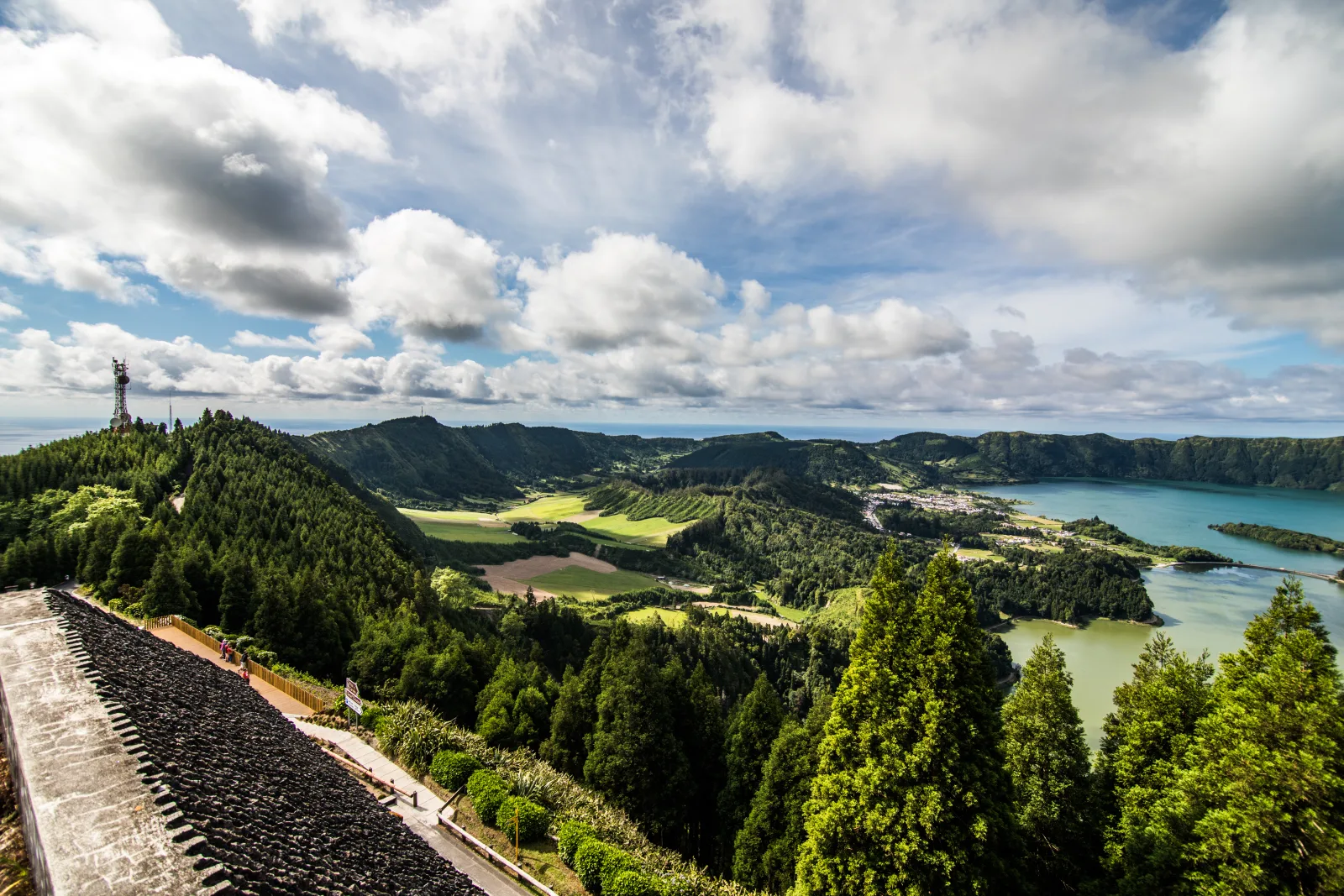
The map shows the nine Azorean islands stretched across the mid-Atlantic — Santa Maria and São Miguel on the eastern edge, Pico/Faial/Terceira/Graciosa/São Jorge in the central group, and Flores/Corvo on the far western edge near North America.
| From | Distance to Ponta Delgada | Flight time |
|---|---|---|
| Lisbon, Portugal | 1,500 km | 2h 15m |
| London, UK | 2,500 km | 4h |
| Boston, US | 3,900 km | 4h 30m |
| New York, US | 4,200 km | 5h |
| Toronto, Canada | 4,300 km | 5h |
| Reykjavik, Iceland | 2,900 km | 4h |
If you draw a triangle from New York to Lisbon to Reykjavik, the Azores sit roughly in the middle. That’s why they were the staging point for transatlantic shipping in the 16th-18th centuries — and why some early transatlantic flights still stop in the Azores for fuel.
The archipelago itself stretches across about 600 km of ocean. Santa Maria in the far east to Corvo in the far west is roughly the same distance as Lisbon to Madrid.
What country are the Azores part of?
Portugal. Fully part of Portugal, fully part of the European Union, and fully part of the eurozone.
The Azores have been Portuguese since the islands were first settled in the 1430s — Portuguese navigators arrived a few decades before Columbus crossed the Atlantic. The islands have never been colonized by anyone else, have stayed Portuguese-speaking from the start, and have been Portuguese-administered ever since.
Today they’re an Autonomous Region of the Portuguese Republic, which means:
- Same passport as Portugal — EU/Schengen rules apply
- Same currency as Portugal — the euro
- Same language as Portugal — Portuguese (with a strong local accent)
- Different government for local affairs — regional president, regional parliament, regional laws on things like fisheries, agriculture, education
So when Americans land at Ponta Delgada airport, they’re entering Portugal and the Schengen area at the same time. Same rules as flying to Lisbon — 90 days visa-free for US citizens, same customs, same EU passport stamp.
For a more practical breakdown of what “Portugal’s Atlantic islands” actually means for a traveler, the Azores vs Madeira guide covers the differences between the two Portuguese island chains.
Where are the Azores located? (The real geography)
The Azores sit on the boundary of three tectonic plates — the North American, the Eurasian, and the African.
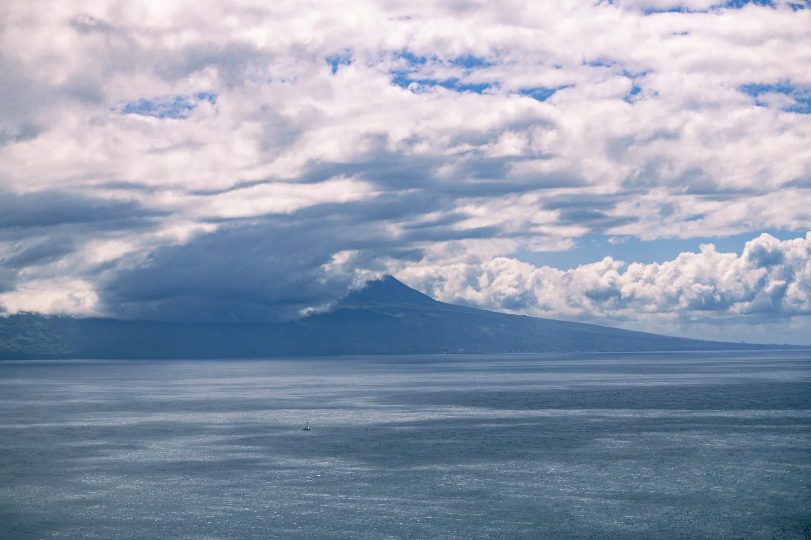
This is why the islands are volcanic, why Furnas has hot springs, and why Pico Island is built around a 2,351-metre stratovolcano (the highest mountain in Portugal). The mid-Atlantic ridge runs right through the archipelago — divers can see exposed lava formations along the underwater fault line on the scuba sites around Pico and Faial.
The nine islands are grouped into three clusters:
| Group | Islands | Size |
|---|---|---|
| Eastern | São Miguel, Santa Maria | Big main island + small quiet sister |
| Central | Terceira, Graciosa, São Jorge, Pico, Faial | Five islands, very close together |
| Western | Flores, Corvo | Two remote islands, far west |
The Eastern Group is closest to Europe and gets ~75% of all Azores visitors (mostly São Miguel). The Central Group is where multi-island trips happen — Pico, Faial, and São Jorge are connected by frequent ferries. The Western Group is wild, remote, and rarely visited — getting to Corvo (population: ~430) is a small adventure even from another Azorean island.
The deep-water position also makes the Azores one of the best places in Europe for whale watching — sperm whales, blue whales, and several dolphin species pass through these waters year-round.
Are the Azores in Europe or North America?
Politically, Europe. Geographically, it’s complicated.
Here’s the wrinkle most maps don’t show: Flores and Corvo (the Western Group) sit on the North American tectonic plate. São Miguel and Santa Maria are on the African plate. The Central Group is on the Eurasian plate.
So if you stand at the western edge of Flores, you’re geologically in North America while politically in Europe. The Atlantic mid-ridge is what separates them — and you can see it underwater off the coast of Pico if you’re scuba diving the right sites.
For travel categorization purposes, the Azores are treated as European across the board — EU passport rules, European travel insurance, European data roaming, .pt domain extensions, eurozone currency. The continental geography quirk is a fun fact, not a practical concern.
How do I actually get to the Azores?
Three main routes:
From the US
Direct from Boston is the cheapest and fastest. Azores Airlines (SATA) and JetBlue both fly Boston-Ponta Delgada year-round. Flight time is 4 hours 30 minutes. Round-trip fares are usually $400-$900 in shoulder season, $700-$1,400 in peak summer. Booking 8-12 weeks ahead helps.
Direct from New York runs seasonally on JetBlue. Less reliable than Boston, more expensive. Other US cities require a connection, usually via Boston or Lisbon.
From Canada
Direct from Toronto runs year-round on Azores Airlines. Montreal seasonally. Flight time is 5-5.5 hours. Halifax has occasional summer charters but isn’t reliable.
From Europe
Lisbon-Ponta Delgada is the most-flown route, with multiple daily flights on TAP Portugal, Azores Airlines, and Ryanair. Lisbon-Ponta Delgada is 2h 15m and the cheapest fares are typically Ryanair at €30-€80 each way booked 4-6 weeks ahead.
Other European cities with direct seasonal flights: London (multiple airports), Frankfurt, Paris, Madrid, Amsterdam, Copenhagen.
The full breakdown of all four passenger airports — PDL, Pico, Faial, Terceira — is in the Azores airport guide, including which airport to fly into based on which islands you want to see.
Is the Azores a country? (The short answer)
No. The Azores are an Autonomous Region of Portugal, not an independent country.
But they do have an unusual amount of self-governance. The regional parliament (in Horta on Faial) writes laws that apply to the Azores specifically — particularly around fisheries, agriculture, tourism, and education. The regional government is based in Ponta Delgada. The judiciary sits in Angra do Heroísmo on Terceira.
This is similar in structure to how Madeira works — both are Autonomous Regions of Portugal with regional governments. They’re not Portuguese in the same way Porto or Lisbon are. They’re Portuguese with significant local autonomy.
What is the capital of the Azores?
Three cities split the role.
| City | Island | Function |
|---|---|---|
| Ponta Delgada | São Miguel | Seat of the regional executive (President of the Regional Government) |
| Horta | Faial | Seat of the Regional Legislative Assembly (regional parliament) |
| Angra do Heroísmo | Terceira | Seat of the regional judiciary, UNESCO World Heritage city |
For most travelers, Ponta Delgada is the practical capital. It’s the largest city (~70,000 people), has the international airport, and is the political and economic centre. It’s where the regional government works day-to-day.
Angra do Heroísmo on Terceira was historically the first capital — a UNESCO city built in the 16th century when Terceira was the most strategically important island for transatlantic shipping. Worth a visit if your trip includes Terceira. It’s one of the prettiest old cities in the Atlantic.
What time zone are the Azores in?
The Azores observe their own time zone: Azores Time (AZOT, UTC−1) in winter, Azores Summer Time (AZOST, UTC+0) in summer. They observe daylight savings on the same dates as the rest of Europe.
What this means in practice:
| Season | Lisbon | Ponta Delgada | New York |
|---|---|---|---|
| Winter | UTC+0 | UTC−1 | UTC−5 |
| Summer | UTC+1 | UTC+0 | UTC−4 |
So the Azores are 1 hour behind Lisbon, 4 hours ahead of New York in winter, and 5 hours ahead in summer. Coming from the US east coast, the time change is mild — you lose 4 hours flying east, which is much less brutal than the 6-7 hours to mainland Europe. This is part of why the Azores work well as a long-weekend trip from Boston.
What language do they speak in the Azores?
Portuguese. With a strong local accent that even mainland Portuguese sometimes struggle with — Azorean Portuguese has its own pronunciation patterns and a handful of words you won’t hear in Lisbon.
English is widely spoken in tourist-facing places: hotels, restaurants in Ponta Delgada and Horta, tour operators, car rental desks at the airport. Outside the main towns, English is hit-or-miss. Most younger people speak it. Older locals often don’t.
Spanish gets you partway. French is occasionally understood. German not really.
If you want to be the polite tourist, learning “obrigado / obrigada” (thank you), “bom dia” (good morning), and “se faz favor” (please) goes a long way. Locals are friendly and patient with imperfect Portuguese.
Why do people get confused about the Azores?
A few legitimate reasons.
1 — They’re not on most world maps. The Azores are tiny dots in the middle of the Atlantic. Many maps just show them as ”…” between Europe and the Americas. Modern Google Maps does a better job.
2 — The Portugal connection is non-obvious. People assume Atlantic islands belong to whoever is closest geographically. The Azores being Portuguese (rather than American, Canadian, or independent) surprises a lot of first-time visitors.
3 — Confusion with Madeira. Madeira and the Azores are both Portuguese Atlantic island groups, but they’re 1,000 km apart and have completely different climates and cultures. Madeira is warmer, drier, more touristy. The Azores are greener, cooler, and quieter. The Azores vs Madeira comparison covers it in detail.
4 — Confusion with the Canary Islands. The Canaries are Spanish, sit off the coast of Morocco, and are sub-tropical. The Azores are Portuguese, in the mid-Atlantic, and temperate. Different country, different climate, different vibe.
5 — Confusion with Cape Verde. Cape Verde is an independent country off the coast of West Africa. Portuguese-speaking, but not Portuguese. Tropical climate, very different culture. Easy to mix up the names if you’re new to the region.
6 — The “where exactly” question. Even people who know the Azores are Portuguese sometimes underestimate the distance. The islands aren’t a short hop off the Portuguese coast. They’re a proper Atlantic crossing — closer to mainland Portugal than to anywhere else, but only just. From the air, you fly over a lot of ocean before you see land.
If you’d rather skip planning the logistics yourself, Pocket Guide Azores is the AI travel planner that handles airport choice, ferry timings, weather windows, and which islands to combine — all built on local knowledge from someone who lives here.
The bottom line
The Azores are nine Portuguese islands in the middle of the Atlantic, about 1,400 km west of mainland Portugal and a 4-5 hour flight from Boston. They’re part of Portugal, the EU, and the eurozone. They have their own time zone (one hour behind Lisbon), their own regional government, and a geography that puts them on the boundary of three tectonic plates.
For a first trip, fly into Ponta Delgada (PDL) on São Miguel — that’s the international gateway and the biggest island. From there you can either stay on São Miguel (the easiest trip) or hop to Pico, Faial, or Terceira for a multi-island experience.
What to read next
- Azores airport guide — flight routes, codes, and ground transport from PDL.
- Best time to visit the Azores — when to come and why it matters.
- Azores vs Madeira — which Portuguese island chain fits your trip.
- How many days in the Azores — once you’ve decided to come.
- Where to stay in São Miguel — Ponta Delgada vs Furnas vs the coast.
Frequently asked questions
Where are the Azores located? +
The Azores are an archipelago of nine volcanic islands in the middle of the North Atlantic Ocean, roughly 1,400 km west of mainland Portugal and about 4,000 km east of New York. They sit on the boundary of three tectonic plates (North American, Eurasian, and African) and are part of Portugal — though geologically they're closer to North America than Europe. The capital, Ponta Delgada, is on São Miguel, the largest island.
What country owns the Azores? +
The Azores are part of Portugal. They've been Portuguese since the islands were first settled in the 1430s and are officially an Autonomous Region of the Portuguese Republic, with their own regional government and parliament based in Ponta Delgada. The currency is the euro, the official language is Portuguese, and EU citizens travel here without a passport. So yes — the Azores are Portuguese, fully part of the EU, and use the same passport rules as Lisbon.
How far are the Azores from Portugal? +
The closest point of the Azores (Santa Maria island) is about 1,360 km from mainland Portugal. Ponta Delgada (São Miguel) is around 1,500 km from Lisbon. Direct Lisbon-Ponta Delgada flights take 2 hours 15 minutes. The archipelago itself is spread across roughly 600 km of ocean — Santa Maria in the east to Flores and Corvo in the far west. So 'the Azores' is less a single dot on the map and more a band of islands stretched across the mid-Atlantic.
Are the Azores in Europe or North America? +
Politically, in Europe — they're part of Portugal, the EU, and the eurozone. Geographically, it's more complicated. The Azores sit on three tectonic plates: Santa Maria and São Miguel are on the African plate, the central group sits on the Eurasian plate, and Flores and Corvo are technically on the North American plate. So if you stand on Flores, you're geologically in North America while politically in Europe. Most maps and travel categories treat the Azores as European.
How many islands are in the Azores? +
Nine inhabited islands plus a handful of uninhabited islets. They're grouped into three clusters by location: Eastern Group (São Miguel and Santa Maria), Central Group (Terceira, Graciosa, São Jorge, Pico, and Faial), and Western Group (Flores and Corvo). São Miguel is the largest and gets the most visitors. Each island has its own character — Pico has the highest mountain in Portugal, Faial has the famous yacht harbor, Terceira has the oldest city in the Azores.
Is the Azores a country? +
No. The Azores are an Autonomous Region of Portugal, not an independent country. They have their own regional government — the Regional Legislative Assembly meets in Horta on Faial, the executive sits in Ponta Delgada — and significant self-governance over local affairs. But they share Portugal's currency, EU membership, foreign affairs, defense, and passport. Think of the Azores' relationship to Portugal as similar to Hawaii's relationship to the US — distinct character, same country.
What is the capital of the Azores? +
Ponta Delgada on São Miguel is the seat of the regional executive government and the largest city. Horta on Faial is where the Regional Legislative Assembly meets. Angra do Heroísmo on Terceira is the seat of the regional judiciary and a UNESCO World Heritage city — historically the original capital before the function split across the three islands. So depending on what part of government you mean, there are technically three capitals. For travel purposes, Ponta Delgada is the one you'll fly into.
What time zone are the Azores in? +
The Azores are in the Azores Time Zone (AZOT, UTC−1). That's one hour behind Lisbon and one hour ahead of New York in winter, or the same as New York in summer (Eastern Daylight Time). The Azores observe daylight savings — when Lisbon springs forward, so does Ponta Delgada. This is why direct US flights from Boston feel like they take less time than the clock says — you gain hours flying east. Coming back is the rougher direction.